|
 |
CONTENTSOF
THE SECOND VOLUME.CHAPTER VII.
*This chart has been added by the transcriber to provide reference for Marchand's digression on the islands discovered by the Spanish navigators. It has been taken from George Anson's A voyage round the world, in the years MDCCXL, I, II, III, IV, London: Knapton, 1748. | ||||||||||||||

Sandwich Islands. according to Cook.
|
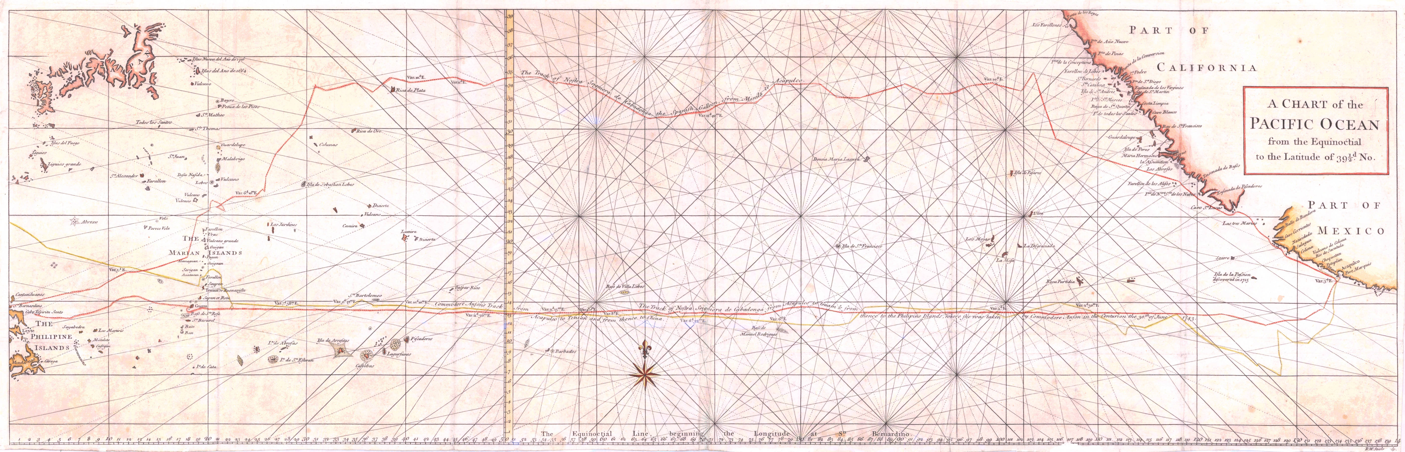
A Chart of the Pacific Ocean, from the Equinoctial, to the Latitude of 39 degrees and a half North.
|
A
VOYAGE ROUND THE WORLD,
DURING THE YEARS 1790, 1791, and 1792.
CHAPTER VII.
The run from the coast of America to the Sandwich Islands is equally destitute of interest and variety: Captain Marchand and Captain Chanal made it their constant business to |
ascertain by frequent observations of the moon's distance from the sun, and by the daily observation of the meridian altitude of this latter luminary, what was the gradual progress of the ship in longitude and latitude; and by this series of observations, they were confident of making a more direct course, and of precisely hitting the islands which it was intended to make. In this run, as well as in all those which had preceded it, they never neglected to determine the variation of the magnetic needle, as frequently as the weather would allow, either by azimuths, or by easterly or westerly amplitudes. The results of their different observations are to be found in the Notes that accompany this narrative, and in the Journal of the Route, which presents the data of the calculation*. I shall content myself with mentioning two remarks, which might give rise to a presumption of the existence of some islands that have not yet been perceived, or rather met with again. In the night between the 14th and 15th, there was taken with the hand, a small land-bird spent with fatigue, which had settled on one of the yards. The latitude of the ship, at this period, was 40° 15', and her longitude, correcting it by the observations made five days after, must have * See, towards the end of this Volume, Notes XLV to LI, and the Journal of the Route at the dates of the observations of which the Notes present the calculation and the results. |
been about 133° 45'. The nearest known lands, those which lie to the northward of Cape Mendocino, were distant from the ship about a hundred and twenty leagues to the eastward. This distance of a hundred and twenty leagues is very considerable for a small land-bird, unless it was of the species of those which, as is related of swallows, although belonging to the land, contrive to rest themselves on the water, when the length of the passage exceeds the strength of their wings. However, it would not be astonishing that, in latitudes hitherto little frequented, there should exist some small islands which, not being placed within reach of the tracks that have been followed by the known navigators of these latter times, might not have been perceived; yet such islands might have afforded a retreat to these little birds which, being granivorous, or living on terrestrial insects, could not subsist on the water, and are obliged to go and seek their food on the land. It might happen too that the Spaniards, in their ancient expeditions, had discovered in these latitudes, some islands with which they must have been acquainted before other nations; but it is probable that we shall have no knowledge of the existence of any, and that we shall not ascertain where they are situated, till chance shall have led some navigators, of a nation more communicative than that which made the first discoveries, to find them again. |
The sequel of the Solide's voyage furnishes us with a second remark of the same kind. On the 18th of September, in the afternoon, the ship had reached the latitude of 32° 30' north, and the longitude of about 139° west: this position compared to that of the two nearest lands, placed her three hundred and seventy leagues from the Sandwich Islands, and three hundred and thirty from Drake's New Albion. It was at this distance from known lands, that a small land-bird, of the species of the canary, was seen to alight on one of the ship's yards. It could not be supposed that so small a bird could have come even from the nearest known land, that is to say, that it could have made, all at one flight, a passage of three hundred and thirty marine leagues: it was therefore presumed that, in the north-east quarter, whence the wind blew, there exists some island, still unknown to modern navigators, to which this little bird belonged. I have looked whether some ancient navigator might not indicate to us in this latitude, some solitary island that had not yet been found again: I see on the Manilla galleon's chart, constructed from the private memoirs of the Spaniards, which Commodore Anson seized upon, in 1743, when he took possession of that ship, and which he has since published in the account of his voyage round the world; I say, I see a small island under the name of Isla de los Paxaros (Island of Birds), |
The general chart of Captain Cook's third voyage, places it in the latitude of 26° 30', like that of the galleon, and in the longitude of 137° 20'; I know not on what authority. This situation would bring it nearer to that of the Solide, which would be at no greater distance than one hundred and twenty-three leagues and a half to the north 13 or 14° west of it†. The passage will, no doubt, *
According to the observations of the Abbé Chappe, in 1769, San Joseph is 112° 2' 30" west fromParis (Voyage en Californie,Paris, Jombert, 1772, 4to. page 85 to 88.) |
appear still too long for a Canary-bird, especially when it is not wafted by a favourable wind which supports its flight, but, on the contrary, has to struggle against a strong resistance. Ali that it is allowable to conclude from this discussion, is, that it is very probable that the Spaniards have formerly seen an island in a latitude which is not very remote from the situation occupied by the Solide on the afternoon of the 18th of September; and that this island must have been distinguished by the multiplicity of its birds, since the navigator, who discovered it, imposed on it the name of Isla de los Paxaros: but, at present, what is the true position of this island? This is a problem which I leave to be solved by navigators who, in the sequel, may frequent these seas: I could only point out to them the possibility of a discovery. We must, however, here recall to mind the story of the golden tooth*: might it not really happen that this little bird, whose unexpected appearance leads the geographer into dissertations, was nothing more than a canary that had, perhaps, belonged to a ship pas-
* After some of the greatest naturalists and philosophers in Europe had been long employed in endeavouring to account for the existence of a golden tooth in a living subject, they at length discovered, with wonderful sagacity, that the tooth was a false one. — Translator's Note. |
sing by, from which it might have made its escape? On the 21st of September, our voyagers began to see tropic-birds and quebranta-huessos or giant-petrels*. On the 3rd of October, at half past two o'clock in the afternoon, the longitude of the ship, deduced from a mean between two sets of lunar observations, was 155° 17' 30", and the latitude observed at noon, and reduced to the period of the observations for the longitude, was 19° 13' 30" north: according to this position, the east point of O-Whyhee, the largest and the most eastern of the Sandwich Islands, must have borne west by north, at the distance of thirty-six leagues; and Captain Marchand might promise himself to have sight of it the next day in the course of the forenoon. He navigated during the night with the precautions required by the search of land, without granting to the result of the astronomical observations, a degree of precision above that which is admitted by the method employed for determining the longitude, and allowing something for the uncertainty which always remains respecting the estimate of the portion of the way that a navigator is obliged to introduce into the calculation, from the time of his last observation till he gets sight of the land. * Procellaria gigantea, Latham, — Translator. |
The next day, the 4th, at ten o'clock in the morning, O-Whyhee was discovered as Captain Marchand had expected: it bore from west by north to north-west by west; and he crowded sail in that direction. At four o'clock in the afternoon, the ship was exactly under the meridian of the most eastern point of the island, which, according to the observations made on board the Resolution and the Discovery, in Captain Cook's third voyage*, is situated in 157° 10' 15" west fromParis: the longitude of the ship deduced from the observations of the preceding day, was 157° 1': thus, the error on making the land was only 9 minutes, or somewhat less than three leagues; and it is to be observed that these 9 minutes of error may belong to the portion of the way that our navigators were obliged to estimate, from noon of the 3rd, to which the lunar observation had been reduced, to the time of taking the bearing of the east point of the Island of O-Whyhee†. As for the longitude by account at the time of making the land, such as it was deduced from the dead reckoning from the Solide's point of departure off Berkley Sound, it was found to be * The original astronomical Observations made in the course of a Voyage to the Northern Pacific Ocean &c. By W. Bayly. London, 1782. 4to. page 350. |
in error 1° 32' 45" or twenty-nine leagues ahead; but this error would have been greater by thirty-six minutes, or eleven leagues and one third, if the sum of the errors astern had not balanced part of the sum of the errors made in a contrary direction*. In the morning of the 5th, the Island of O-Whyhee, being free from the clouds which, the day before, covered a part of it, shewed itself plainly: Mowna-Roa and Mowna-Kaa, two most remarkable mountains, situated in the interior of the island, the former and the highest, towards the south, the latter, towards the north-east quarter, were distinctly seen: but no snow was perceived on any of the most elevated points that presented themselves to the view. This remark does not accord with what Captain King says in Cook's third voyage, that the summits of these mountains are constantly buried in snow†: it appears that he was wrong to infer their habitual and constant state, from that in which he saw them in the month of March, that is to say, at the beginning of the spring; it is certain that the French who saw them not till the beginning of the autumn, perceived no snow on any part of them. But, doubtless, in the latitude of 19° north, the summer suns must produce a change, in the interval from the month of March to the month of October. * See Note LI. |
When the mountains, disengaged from clouds, were distinctly discerned from the Solide, she was at the distance of five leagues from the south-east coast. In this situation, Mowna-Roa shews itself in a manner particularly remarkable, because its summit, which extends on an east and west line, forms a lengthened platform, in the shape of a long dining-table; and from this flat summit, its sides stretch by a gentle declivity till they meet the seashore. At eleven o*clock, the ship doubled the south side of O-Whyhee. Towards noon. Captain Marchand shortened sail, in order to wait for a canoe that was steering for the ship: in it were three islanders; but they had only some fish, which was, much to their satisfaction, paid for with a nail. The Sandwich Islands are too well known by the voyages of Cook, Portlock, Dixon, Meares, Douglas, and other English navigators who have frequented them; and La Pérouse's journal will add too many details to those which we already possess, for me to think it necessary to dwell on what concerns their soil and inhabitants: the Island of O-Whyhee, in particular, has acquired a deplorable celebrity; it bears a spot of blood which ages will not efface*. * It is well known that Captain Cook was massacred in this island. |
These islands may be considered as a large caravansary, placed on the route of the ships which cross the Great Ocean between the parts of Asia and America situated to the northward of the line. Several of the navigators who have made them of late years, have, through the medium of canoes, without landing, and while under sail, procured the refreshments, and even the water and wood, with which they wished to be supplied. The danger incurred, a few years ago, by an English captain, who, through a concerted piece of treachery, had like to have lost there both his crew and his vessel, ought to render circumspect those that may be induced to present themselves with strength which would not be sufficient for awing the natives or repelling an attack. We can only recommend the Europeans who frequent the Great Ocean, not to anchor at these islands, but to receive from the canoes, those provisions which the islanders will always be eager to bring to them on board. The health of the crews has every thing to lose, if they go on shore; and the natives have nothing to gain, for the preservation of their race, by a too immediate communication with the seamen of civilized nations. Captain Marchand formed the prudent resolution of making all his purchases under sail, and confined himself to trading with the Island of O-Whyhee alone, which was sufficient for all his wants. Thence he procured hogs, a small quan- |
tity of poultry (fowls were scarce and dear}, cocoa-nuts, plantains, sweet potatoes, yams, sugarcanes, and the other fruits and productions natural to these islands. It must have been an agreeable surprise, to see that, with the indigenous productions, were mixed pumpkins and water-melons, fruits of a species which, not belonging to the soil of the Sandwich Islands, must have come from the seeds sown by the English or by La Pérouse. More prudent, or less improvident than the inhabitants of the islands situated south of the line, those of the islands north of it have been sensible of what utility it would be to them to multiply this new mean of subsistence: and the Europeans, in making to the Sandwich Islands this useful present have, by an act of beneficence, served their own interest for the future. It was remarked that the canoes which came from O-Whyhee to traffic with the ship, never failed to bring women intermingled with the hogs, and offered them, conjointly with the filthy animal, among the refreshments which the natives proposed to the strangers; however, the Solide's crew were prudent enough to content themselves with the eatables. Surgeon Roblet observes that the hogs appeared to him to be of two species: the most numerous and the smallest is that described by Captain Cook, and by Captain King, who continued his narrative; the only one, no doubt, with |
which they were acquainted: the other, less common, is of a large size; and the French observer is inclined to think that this is the former species, improved by a mixture with some European hogs. Without wishing precisely to combat this opinion, I shall only say that it seems to me by no means probable that the Europeans have ever thought of depositing hogs on islands where they have found them so numerous, and where they did not arrive till after long voyages which, doubtless, had not allowed them to make any savings out of their provisions. The same observer endeavours to destroy an opinion which the English voyagers appear to have established, that the hogs of the Sandwich Islands cannot live on shipboard, and that, in order not to lose them, it is necessary to make haste to kill and salt them*: on this subject, he relates that, out of fifty of these animals which were kept alive on board of the Solide, not one refused to take nourishment: and those which were not killed till after having been several days at sea, had * Captain King has most minutely described the particular method which Captain Cook first put in practice to succeed in salting pork in the countries situated between the tropics, where putrefaction makes its appearance so quickly, that vain would be the attempt to salt down provisions in employing only the ordinary process. Captain Portlock and Captain Meares have likewise explained the methods which they themselves have practised with success; these differ little from that of Captain Cook.— (See Cook's Third Voyage, Vol. III. pages 11 and 12 — Portlock's Voyage, pages 88 to 90 — Meares's Voyages, page 277.) |
by no means wasted away, and appeared to be in full as good condition as when they had been taken on board. Iron is almost the only article which the natives chose to accept in exchange for their provisions. They set a great value on large spikes; but it is difficult to paint the transports of their joy, when, in the room of three or four nails, a large joiner*s plane was given them as the price of one of their largest hogs: they must already know for how many uses this tool can be employed. The passion of these people for iron is of no recent date; for it appears that on the first visit which they received from the Europeans in 1778, they were already acquainted with the utility of this metal; and they expressed the greatest eagerness to acquire it. It might thence be conjectured that the hazards of navigation, the shipwreck of some vessel coming from America and run ashore on their islands, gave them in more ancient times a knowledge of iron; and that, having experienced, by use, the superiority of this metal to hard stones, the fragments of shells, bones of animals, &c. for making tools and weapons, it is, of all European merchandise, become that which must have most excited their wishes. Surgeon Roblet remarked, however, that, among a rather considerable number of islanders who came to traffic on board of the Solide, and with whom our voyagers |
saw not in the hands of any one of them, a single weapon, or implement made of iron. It would be a matter of curiosity to know for what use and how they employ those large spikes, those pieces of bar or sheet iron which they seek after with such avidity. It is not probable that they have already found out the manner of fashioning these; and although the first English ships that visited them may possibly have given them some idea of the labours of the forge, this simple notion falls far short of the employment of the means; a man is not a smith from having seen smith's work executed. If, in the sequel, European navigators should continue to perceive no weapon, no implement of iron in the possession of the natives who come on shipboard, would it be too bold a conjecture to suppose that the chiefs or Earees of each island, who appear to exercise the greatest authority, make it their business, either through policy, or through an effect of their cupidity, to get all the iron from the hands of the islanders, and form of it, as it were, hoards; as we see the Princes of Asia bury the precious metals which commerce with Europeans annually introduces into their country? Before we quit the Sandwich Islands, I shall take the liberty of making a digression respecting the period of their discovery by the Europeans. those who have read no other account than that of Cook's third voyage must believe that this disco- |
very incontestably belongs to that celebrated navigator; but it can be proved that it belongs more anciently to the Spaniards, as well as several other discoveries in the Great Ocean, which ignorance or policy had suffered to be lost, and which the interest and activity of the navigators of our days have led them to bring to light again. I shall not adduce as one of the titles of the Spaniards to the first discovery of the Sandwich Islands, that in 1568, Mendana discovered in the latitude of 19^ 20' north, and 150° west from the meridian ofParis, according to the Spanish charts, an island by them named San Francisco*, situated in the parallel of these islands; to this, the obscurity of ancient narratives would justly be objected; besides, the knowledge of an island in the same latitude as the group of the Sandwich Islands, proves not the knowledge of that very group; and it might thence merely be concluded that, in the parallel of those islands, more to the eastward or more to the westward, there exist some other islands. But I examine the Spanish chart of the Manilla galleon†; there I see in the parallel of the Sandwich Islands, about 18° to the eastward of * Hechos de Don Garcia de Mendoça, &c. Por el. Dr. Suares de Figueroa, p. 235. — Herrera. Descrip. de las Indias Occid. chap. 27. — Lopes Vaz and others. |
Mendana's Island of San Francisco, a group composed of four principal islands, and of some others of smaller extent: the most southern is also the largest: the middle of this island is in the latitude of about 19° 20'; it is called La Mesa: to the north-west of this, are seen two somewhat considerable islands, grouped with four others much smaller: the six together are designated by the collective word of Los Monjes* (the Monks): from the middle of La Mesa to the middle of the group> we may reckon about forty leagues. Let us at present examine the eastern group of the Sandwich Islands: for it is well known that these islands form two distinct groups; the Western group which was explored by Cook in January 1778, in his run from the Society Isles to the north-west coast of America, and the Eastern group of which he had no knowledge till his return from that coast in the month of November following. The eastern group is, like that of La Mesa of the Spaniards, composed of four principal islands and of a few others of less extent: the southernmost island, O-Whyhee, is also the largest: the * On the copy of this map, published by Commodore Anson we read los Mojos, in lieu of los Monjes; this is a mistake; D. Tomas Lopez, on his Mapa de America 1772, writes Los Monjes, and it is well known that this denomination of Los Monjes (the Monks) is not rare on Spanish Maps for designating small islands assembled in a group. |
most remarkable part of this island, the high mountain of Roa, is, like the middle of La Mesa of the Spaniards, situated nearly in the latitude of 19° 20': to the north-west of O-Whyhee, as well as to the north-west of La Mesa, are two somewhat considerable islands, grouped with three other smaller islands; only, the small islands are not here three in number; and we reckon four in the Spanish group: from the middle of O-Whyhee to the middle of its group, as well as from the middle of La Mesa to the middle of the group to which it belongs, we reckon forty leagues: in short, both groups alike occupy from two to three degrees in latitude, and upwards of three degrees in longitude. Thus, it is seen that, to describe the eastern group of the Sandwich Islands, I have had only to repeat what I had said in describing the group of La Mesa: the same latitude, the same bearing of the islands with respect to each other, the same number, the same disposition, the same total extent: it is not possible to unite more characteristics of identity. To these geographical, and, unquestionably, sufficient proofs, I shall add another which is not without some weight; but which, however, I should have offered as a probability rather than as a proof, were it not supported by the former. First, I observe that the principal island of the group on the Spanish chart is called La Mesa, |
in English the Table, I observe, in the second place, that this name of Table is an appellative name which navigators are accustomed to employ for the purpose of designating a mountain whose summit is flat: every one has heard of the Table-mountain, of the Cape of Good Hope; on the coast of Spain, in the Mediterranean, we find Orlando's Table, &c. Thus, it cannot be doubted that the Spaniards were determined to impose on their island the name of La Mesa, because it was remarkable from some great mountain terminated by a platform, by a Table, But the Island of O-Whyhee which answers, in one group, to the Island of La Mesa in the other, is alike remarkable, as has been seen, from a great mountain whose flat summit represents a long table; the natives call it Mowna-Roa, from the generic name Mowna (mountain) and from the word Roa, extended, or of a great extent. May not this similitude of the two mountains, in a particularity, in a figure which is not very frequently met with, be admitted as a fresh proof of the identity of the two groups? I am not disposed to believe that it is meant to consider the galleon's chart as not being authentic, and deserving of no confidence; for it is well known that this chart was intrusted only to the captain of the ship, and it was on this chart, that, with his pilot, he regulated his course; and, undoubt- |
edly, it will not be supposed that the Spaniards there placed imaginary islands, especially when we see these islands designated by significative names: those who know the jealous uneasiness of the government of Spain in regard to her possessions in America, and her ancient discoveries in the Great Ocean, will rather be inclined to believe that they have never allowed that all the lands which her navigators have discovered should be laid down on their charts. These lands would there be improperly placed, no doubt, especially in longitude; but at least it would be known that they exist: and more skilful navigators would one day contrive to find them again, and bring us acquainted with them. To the proofs which I have given of the identity of the Sandwich Islands and of the group of La Mesa, will be opposed: 1st. That Cook saw no island, twenty-five leagues to the north-east of O-Whyhee, which can represent to us La Desgraciada, an island situated on the galleon's chart, at that distance and in that bearing, in regard to La Mesa; 2nd. That Cook discovered to the west-northwest, and at the distance of twenty-five leagues from the westernmost of the eastern group of the Sandwich Islands, a second group, composed of two islands and two islots; and that the Spanish chart does not indicate this group. |
To the first objection I answer, that, if La Desgraciada was not perceived by Captain Cook, it is not a proof that it does not exist. When this navigator, in coming from the southward, fell in with the western group of the Sandwich Islands, he did not even perceive the eastern group; still less could he have seen an island situated twenty-five leagues to the north-east of the latter: and when, ten months after, in returning from the northward, he looked for the group which he had visited the preceding year, he met with the eastern group about the middle of its extent from north-west to south-east; he then failed very closely round the Island of O-Whyhee; and it is not very astonishing that he should not have seen an island which, to judge of it from the name that has been imposed on it by the Spaniards, La Desgraciadia, the island unfavoured by Nature, the miserable island, may be a land of no great appearance, and even a low island. If the reader cast his eye on the planisphere published by Arrowsmith in 1794, and on which are marked the tracks of all the navigators in the vicinity of the Sandwich Islands i he will see no one that does not pass too far from La Desgraciada for this island to have possibly been perceived from the ships which have steered these tracks. But I shall add that it is not proved that La Desgraciada was discovered by the same navigator who discovered La |
Mesa; and he who met with the former, could not place it according to his difference of longitude in regard to a group which he did not see, which perhaps he did not even know of, but in the absolute longitude that he assigned to it according to his dead reckoning, since he had quitted the coast of America; and the galleon^s chart must have placed it according to this absolute longitude: now, in this case, it might probably happen that there was a great error in the longitude of La Desgraciada, and that this island which, on the galleon's chart, is seen to differ in longitude, in regard to La Mesa, only a degree towards the east, might differ from it, on the globe, several degrees in the same direction, and perhaps even in a contrary one. As much may be said of an island, called Ulva, which, in the galleon's chart, is laid down in the parallel of 23° north, half a degree to the eastward of the meridian of La Desgraciada. It is a principle which must be admitted, that when two islands have not been discovered by the same navigator, and in the same voyage, in passing from the one to the other, we can depend only on the latitude assigned to each island, that is to say, depend on it within half a degree, but that, in this case, their absolute longitude is so uncertain that we cannot, if we wish to find them again, dispense with getting into their respective parallel, two or three hundred leagues |
astern of the place where the chart fixes their position, and then navigating on this parallel till we succeed in meeting with the island*. To the second objection I answer, that the Spaniards who saw the group of La Mesa, the eastern group of the Sandwich Islands, may very possibly not have seen the two islands and the two islots which form the western group; by the same reason that Cook, (which might appear more extraordinary,) when he saw for the first time the western group, did not perceive the eastern group, although some of the islands which compose it can be seen at the distance of forty or fifty leagues; by the same reason again, that this navigator saw not, thirty leagues to the north-west of his western group, Bird Island and Montagu Island†, which, subsequently to his last voyage, some English navigators have discovered: and if, as may be presumed, the Sandwich Islands are only the summits of a chain of subaqueous mountains, it might so happen that this chain might extend farther to the north-west, and form other islands, * Here we are speaking only of the discoveries of the ancient navigators who determined the longitudes nearly by chance; for the moderns can employ, for fixing the positions of the lands which they discover, means that give to those who know how to employ similar ones, the assurance of finding with facility the places where they wish to touch. |
beyond those which these recent navigators have discovered. It seems to me then that the objections which, in order to do away, or at lead to weaken the idea of the identity of the eastern group of the Sandwich Islands, and of that which the galleon's chart places in the same latitude, in the same number of islands, occupying the same space, and disposed in the same manner, should be supported, on the one hand, on Captain Cook's not having perceived La Desgraciada, on the other, on the Spaniards not having had a knowledge of the western group of the Sandwich Islands, it seems to me, I say, that these objections are established on arguments which cannot bear a discussion. Perhaps it will be objected to me, as a last resource, that the two groups differ too much in longitude, for it to be possible to take them for one and the same group; and, in fact, O-Whyhee, taken at its middle, is, according to the observations of the English, 158° west from Paris, and La Mesa, on the galleon's chart, is 24*^ west from the meridian of San Joseph in California†, and, consequently, 136° west from that ofParis. But this difference of 22° is far from being a proof against the identity of the two groups: who † The longitude of San Joseph, according to the observations of the Abbé Chappe, is 112° 2' 30" west from the meridian of Paris. (See Voyage en Californie, page 85 to 88.) |
does not know that, when the question relates to the ancient discoveries in the Great Ocean, we look only to the latitude which cannot be affected by a very great error; to the whole, and the general disposition of the two groups that we are comparing; to the number, to the distances and to the respective bearings of the islands which compose them; in short, to a union of remarkable particularities, which is not to be found the same in two different groups. The famous Solomon Islands, discovered by Mendana in 1567, partly found again by Bougainville in 1768, in a greater part still by Surville, in 1769*, visited twice, latterly, by Dentrecasteaux†, and whose * See the Découvertes des Français dans le Sud-est de la Nouvelle Guinée. — Paris, Impr. Royale, 4to, 1790, page 85 to 100, 199 to 231. |
geographical position is irrevocably fixed, occupied, for upwards of two centuries, on various hydrographical charts, positions in longitude, the extremes of which differed a thousand marine leagues, or about fifty degrees. Quiros's Tierra Austral del Espiritu Santo, seen and explored for the first time in 1606, by the Spanish navigator of that name, and found again in 1769, by Bougainville, long remained attached to New Holland, of which it was presumed that it must form a part: at this day, it has retired five of repose: he could not withstand fresh attacks, the violence of which was necessarily increased by a voyage of two years under the torrid zone. He sunk, and carried with him the sincere regret of all those subjects to his authority, which he always found means to maintain without ever suffering its weight to be felt. His virtues rendered him dear to his friends, and respected by every one who knew him, as his talents, his courage, and his experience in his profession, and in the details of administration, rendered him useful to his country. The excess of his zeal shortened his days; but, before he terminated a career which he had so honourably filled, he had at least the satisfaction of having brought the dangerous expedition, with which he was intrusted, to such a point, that what remained to be done might be considered in the light of an ordinary voyage. |
hundred leagues to the eastward of that vast country. When a newly-discovered group presents several incontestable characteristics of identity with another, which we know to have been seen in former times, let us beware of saying that it is not the same group, from the sole reason that it was found in a longitude different from that which the first discoverer had indicated only from the erroneous distance at which he supposed it to be from the continent of America, whence he ^had been dispatched. And such has been the fate of part of the insulated discoveries of the Spaniards: daring adventurers, bold in trying fortune and chances, lucky in their course, ignorant in tracing it, satisfied, in short, with having discovered half of the globe, they have left to others the task of finding again what they themselves seemed to have forgotten. In depriving Captain Cook of the barren honour of the first discovery of the Sandwich Islands, I deprive him not of the smallest portion of that fame which he has so justly acquired: I will even say that it is adding, if possible, to his merit; for merit consists in finding what we look for, in having combined the means that might lead to the discovery; and to discover what we were not looking for, is the merit of chance, which ought not justly to be assigned to the share of the navigator whom chance has favoured; it is a borrowed |
merit; and Captain Cook, so rich in his own discoveries, ought to borrow nothing, as he can have nothing to envy in the adventurers to whom we are, before his time, indebted for the shapeless knowledge of the globe. If discoveries immortalize those who have made them, they also immortalize those who have brought them to perfection. Lieutenant Roberts, who constructed the general chart of the third voyage of the English navigator, on which are traced his three Voyages round the World, and towards both poles, has preserved the group of La Mesa of the galleon's chart, and placed it, taken at its middle, 19° east from O-Whyhee and on the parallel of that island: it should seem that, in thus preserving the group discovered by the Spaniards, he was desirous that no one should dare to contest with the English the first discovery of the Sandwichislands. But Arrowsmith, both on his General Chart of 1790, and on his Planisphere of 1794, sacrificing, no doubt, national vanity to evidence, has done justice to this double adoption. As far back as 1786, La Pérouse who, with a view of ascertaining whether there existed any islands to the eastward of the Sandwich group, had made a point of running, in their parallel, three hundred leagues from east to west, neither perceived, over this whole space, any detached island, nor saw any |
sign of land; though from the aspect of the Island of O-Whyhee, and its table-mountain, he had no doubt of its being La Mesa of the Spaniards. But in effacing the group to which La Mesa belongs, and which becomes the eastern group of the Sandwich Islands, Arrowsmith has also totally effaced the Island of Roca-Partida, situated, on the galleon's chart, about one hundred and forty leagues to the east-south-east of La Mesa, and on a parallel less northerly by three degrees and a half: he has merely suffered La Nublada to subsist, whose name indicates a high land, over which clouds hang; and it is laid down a hundred leagues to the eastward and on the parallel of Roca-Partida. This last- mentioned island was discovered, in, 1542 by the Castilian pilot Juan Gaetano, in the first voyage that the Spaniards ever attempted, from the west coast of New Spain to the great archipelago of Asia. Before he had reached Roca-Partida, Gaetano had discovered, on the same parallel, and two hundred leagues to the eastward, according to his reckoning, another island which he had called San Tomas*. This island, situated to the eastward of Roca-Partida, and which bears no name on the galleon's chart, might be that which the modern charts designate by the name of La Nublada. * See Ramusio. Delle Navlgatloni e Viaggi, &c, Venetia, Giunti 1563. Vol, I, fol, 375, verso. |
We are not justified in supposing that La Nublada, or Gaetano's San Tomas, are one and the same island, since the Spanish navigator discovered them successively, in the same voyage, in standing from the eastward to the westward, and imposed on them different names. Hitherto, neither Roca-Partida nor San Tomas, or La Nublada, have been found again; but let us not be in a hurry to efface them from our charts: let us not forget that the Solomon Islands had thence disappeared, since some geographers, supporting themselves on the opinion of the learned Alexander Dalrymple, had supposed that these islands must be the east part of New Guinea: and at this day, the archipelago of the Solomon Islands occupies its particular place on the globe, over an extent of two hundred leagues, forty leagues to the south-east of that New Guinea, with which it was wished to be confounded*. Let us suffer all the islands to subsist which the Spaniards have pointed out to us on their charts or in their narratives, till we have well ascertained their identity with others; let us preserve them, were it only as beacons, which attract the attention of the navigator, and engage him to make researches. * See the Découvertes des Français dans le Sud-est de la Nouvelle Guinée, page. 4 to 19 — 85 to 154 — 201 to 231 — The voyage of Dentrecasteaux has confirmed what was there said of these islands. |
I shall terminate this digression, rather long perhaps, but which, however, is not void of utility, by observing that chronological accuracy, historical truth, and justice, alike require that in placing the Sandwich Islands on the map of the globe, they should no longer be laid down with the erroneous indication of islands discovered by Captain Cook. There might be written above this archipelago: Sandwich Islands, explored, and named by Captain Cook in 1778, formerly discovered by the Spanish navigators: this would be to declare what belongs to the moderns, and at the same time to restore to the ancients what they have a right to claim. I return to the journal of Captain Marchand, He took his departure from the Island of O-Whyhee, on the afternoon of the 7th of October, and shaped his course for China. O-Whyhee and Mowee, the two easternmost islands of the eastern group of the Sandwich Islands, both appear particularly remarkable from mountains of the greatest elevation. In order to estimate, by approximation, the height of their summits above the level of the sea, I shall make use of the greatest distances at which these mountains were perceived from the Solide, distances calculated from the way that the ship had made in sight of the land, and rectified by the observation of the latitude. We find by Captain Chanal's journal, that on the 9th at six o'clock in the morning, he set, at |
the same time, the mountain of the Island of Mowee bearing north-east 2 or 3° east, and that of Mowna-Roa of the Island of O-Whyhee, east by north 2 or 3° east: he reckoned that the ship was then at the distance of thirty-fix leagues from both of them. At half past five o^clock in the afternoon, he still perceived very distinctly the summit of Mowna-Roa, bearing east 2° 30' north, although he was forty-six leagues distant from the west coast of the island, and, consequently, about fifty leagues from the summit of the mountain. If, with this distance of fifty leagues, and regard being had to the depression of the horizon and the effect of terrestrial refraction, it be wished to seek by calculation, what must be the height of the summit of Mowna-Roa, in order to be perceived at the distance of fifty leagues, it will be found that it is 2598 toises, and thence it will be concluded that, next to Chimboraço in Peru whose height is 3220 toises, Mowna-Roa is the highest mountain on the globe: for Pinchincha which occupied the second place, is but 2434 toises; Mount Blanc which occupied the third, 2391; and the Peak of Teyde or Teneriffe, which occupied the fourth, 1905 toises only, according to the trigonometrical and barometrical calculations of Borda*. Mowna-Roa is therefore loftier * See Note II. |
than the Peak of Teneriffe, by 694 toises; and this result would seem to confirm that given by Captain King in the third volume of Cook's last voyage: he says that "this mountain must be at least 16,020 feet high, which exceeds the height of the Pico de Teyde or Peak of Teneriffe, by 724 feet, according to Dr. Heberden's computation, or 3680 English feet or 3452 French feet, according to that of the Chevalier de Borda,*" which gives 575 1/2 toises, less; this differs, in defect, only 19 1/2 toises, from the height that I have deduced from the data furnished me by Captain Chanal's journal. But Captain King obtained his result by a method different from that which I employed to arrive at mine: he took for the basis of his calculation, according to the principle adopted by La Condamine for measuring the heights of the Andes or Cordilleras, the elevation of the line at which the snow remains all the year on the high mountains between the tropics. This method was not applicable to the mountains of the Sandwich Islands, since it has been seen that, in the month of October, there existed no snow on any part of these islands. I therefore consider it as the effect of chance that King's result and mine agree, within a trifling difference. I observe that King, still following the principle which he * Cook's third Voyage, Vol. III. pages 103 and 104. |
adopted, adds that the height of Mowna-Roa must be much greater than that which he assigns to it; for, says he, "in insular situations, the effects of the warm sea-air must necessarily remove the line of snow, in equal latitudes, to a greater height than where the atmosphere is chilled on all sides by an immense tract of perpetual snow." The principle is true, and the application of it would be just, if it had for its object islands where the snow should last the whole year; but it cannot be admitted with respect to those where the snow does not resist the summer suns*. * In not adopting the consequence which Captain King has drawn from the principle on which he rests for deciding that the height of Mowna-Roa must be much greater than that which he determines, and which is, within a trifling difference, the same as that I have deduced from the distance at which its flat summit was very clearly distinguished from the Solide, I am far from pronouncing that the height of the mountain does not exceed the 2598 toises given me by calculation; for Captain Chanal related to me verbally that, on the 10th at sun-rise, several persons belonging to the ship were convinced that they still perceived the Table of Mowna-Roa in a line with the horizon; and, at this period, according to the run which had been made during the night, the Solide must have been fifty-three leagues distant from it at least; which would give to the mountain upwards of 2700 toises in elevation above the level of the sea. Captain Chanal had not thought it necessary to insert this observation in his journal, because he had not been able to see with his own eyes; but he told me that, on other occasions, he had discovered that several of the people had a sight which extended much farther than his. |
The same observer estimates, according to his method, the height of Mowna-Kaa, (the northern mountain of the Island of O-Whyhee) at half a mile or 475 toises; and he adds, that this computation must be too low, for the same reason that he has given for supposing too small the estimation which he has made of Mowna-Roa. Captain Chanal's journal affords us no datum for determining the elevation of Mowna-Kaa, but Surgeon Roblet thinks that the estimation which Captain King supposes to be too low, is, on the contrary, very much exaggerated. In order to find the height of the mountain of Mowee, the second island of the eastern group, we shall calculate according to the distance of thirty-six leagues, estimated by the eye, at which it was perceived on the morning of the 9th; and it will be found that its summit is 1346 toises high: this height is between that of Mount St. Gothard, 1431, and that of the convent on the Great St. Bernard, 1241 toises. The Island of Atooi, the westernmost of the western group, is also very lofty; for, on the 10th, at noon, it bore north-north-west 3 or 4° north; and, according to the latitude of the ship observed at the same instant, and compared with the known latitude of the island, the distance from the ship to Atooi must have been thirty leagues: the height of the mountain is therefore 1216 toises. |
In the interval from noon on the 9th to noon on the 10th, the ship had experienced the effect of a violent current, which had carried her 29 minutes, or nine leagues and two thirds to the northward, as was ascertained by comparing the difference of the latitudes observed on the 9th and 10th, with the difference deduced from the dead reckoning during the same twenty-four hours. Captain Marchand had constantly steered west-northwest 3° 45' north, allowing for the variation; the wind had blown very faintly and unsteadily from the southward during the first five hours; in the night, it had been calm; and, from two o'clock in the morning till noon on the 10th, the wind had stood in the north-east quarter, very faint and baffling; the ship had made very little way through the water: it may therefore be supposed that, as she was abreast of all the channels that separate both the two groups, and the islands of which they are composed, the rapid current which, no doubt, these channels occasion, had acted with all its velocity and strength against the ship whose route crossed its direction; and, by causing her to drift bodily to the northward, although her apparent route was west-north-west, it had carried, her ten leagues in twenty-four in the former direction. On the 11th, at break of day, no land was to be seen. |
The run across the Great Ocean with regular and steady winds, presents only a monotonous series of remarks relative to the velocity and the direction of the currents, and their influence on the ship's course: I have thought it my duty to throw them into the notes; and I invite the nautical reader to consult them*. . . . .
* See Notes LII to LV. |
|
Source.
Étienne Marchand. This volume is available at the Internet Archive.
Last updated by Tom Tyler, Denver, CO, USA, Nov 21 2021.
|

